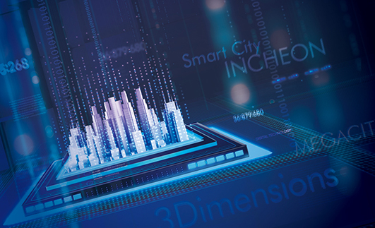
[CONNECT INCHEON] SMART CITY INCHEON A SMART CITY SHAPING A BETTER FUTURE FOR ITSELF AND CITIZENS: INCHEON
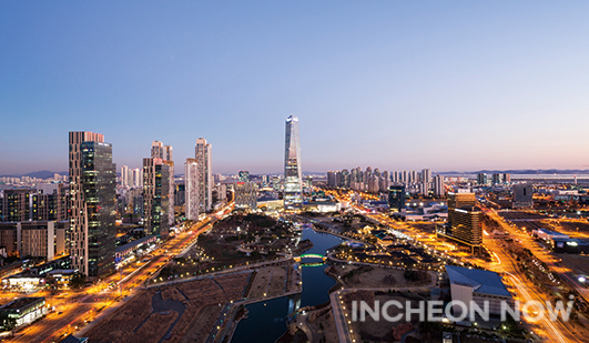
Night view of Songdo International City highlighting its integrated smart technologies.
스마트기술이 집약된 송도국제도시 야경
SMART CITY INCHEON A SMART CITY SHAPING A BETTER FUTURE FOR ITSELF AND CITIZENS: INCHEON
도시 & 시민의 더 나은 미래를 만들어가는 스마트 도시, 인천
Technological progress is redefining urban landscapes, reshaping our daily lives, and shaping the future. Emerging technologies such as information and communication technology (ICT) and big data are driving urban development. Incheon is advancing from mere technology adoption to becoming a smart city that seamlessly connects people with their environment. Let’s explore how Incheon is transforming into a more convenient and safer city.
기술 발전은 도시를 새롭게 정의하고 우리의 일상과 미래를 변화시킨다. 특히 정보통신기술(ICT)과 빅데이터 등 신기술은 도시 성장의 핵심 동력으로 자리 잡았다. 인천은 이러한 흐름 속에서 단순한 기술 도입을 넘어 사람과 도시를 연결하는 스마트 도시로 나아가고 있다. 더 편리하고 안전하게 변화하는 인천의 모습을 살펴보자.
DELIVERING A CUSTOMIZED SMART CITY TAILORED TO LOCAL CHARACTERISTICS
지역 특징에 따른 맞춤형 스마트 도시로 구현하다
Incheon has established a comprehensive plan to build a smart city that citizens can experience in their daily lives. Moving beyond basic technology adoption, the initiative emphasizes urban services that create tangible impact. Approved by the Ministry of Land, Infrastructure and Transport, the plan details phased execution and collaboration across departments.
인천은 시민이 일상에서 체감할 수 있는 스마트 도시 구현을 목표로 종합계획을 수립했다. 이는 단순한 기술 도입을 넘어 생활 속 변화를 이끄는 도시 서비스 구축에 중점을 둔다. 해당 계획은 국토교통부의 최종 승인을 받았으며, 지난 1월 30일 완료보고회를 통해 단계별 추진 방향과 부서 간 협력 방안을 논의했다.
The Incheon Smart City Plan (2025–2029) seeks to achieve balanced growth between historic downtown areas and new developments, fostering an inclusive megacity.
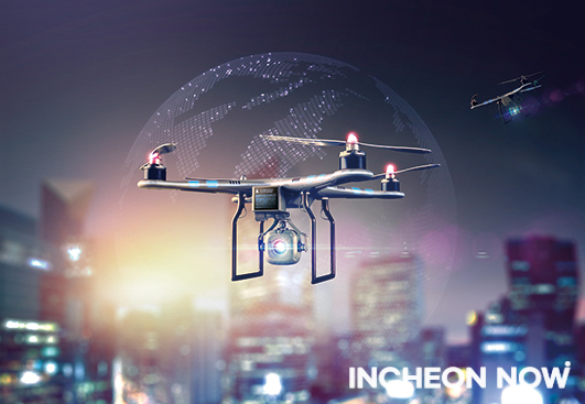
Key services encompass demand-responsive urban air mobility in island regions, drone delivery, the “Safe Dream Service” aimed at women, and AI-powered care solutions for seniors.
Everyday services like smart crosswalks and parking information systems will also be expanded throughout the city.
인천시 스마트 도시 계획(2025~2029)의 핵심 목표는 ‘원도심과 신도시의 균형발전’과 ‘모두가 함께하는 메가시티 구현’이다. 주요 서비스로는 도서 지역 중심의 수요응답형 UAM 서비스, 드론 택배 등이 포함된다. 또한 여성 대상 ‘안심드림 서비스’, 노인을 위한 돌봄 플러그 및 AI 안부확인 서비스 등 시민 맞춤형 복지 서비스도 함께 추진된다. 이와 함께 스마트 횡단보도, 주차정보 제공 시스템 등 생활 밀착형 서비스가 인천 전역에 확대될 예정이다.
ADVANCING TOWARD A GLOBAL SMART CITY
글로벌 스마트 도시로 도약하다
Incheon is implementing a range of initiatives to boost its global competitiveness, including establishing smart city special zones, acquiring international certifications, and hosting global symposia. By enhancing data-driven urban management and developing its Integrated Operation Center, the city seeks to create a more efficient system while fostering a private-sectorconnected ecosystem.
Incheon will implement customized smart city solutions tailored to each district and county, supported by eight strategic directions and 41 action plans.
인천은 글로벌 경쟁력을 갖춘 스마트 도시로 도약하기 위해 다양한 정책을 추진하고 있다. 스마트 도시 특화단지 지정, 국제 인증 획득, 국제심포지엄 개최 등을 통해 인천형 스마트 도시 모델을 구축할 계획이다. 특히 데이터 기반 도시 운영을 강화해 민간과 연계된 산업 생태계를 조성하고, 도시통합운영센터를 고도화해 보다 효율적인 도시 관리 체계를 구축해 나갈 예정이다. 이를 위해 8대 추진전략과 41개 실행 과제를 수립했으며, 군‧구별 지역 특성을 반영한 맞춤형 스마트 도시를 단계적으로 구현할 방침이다.
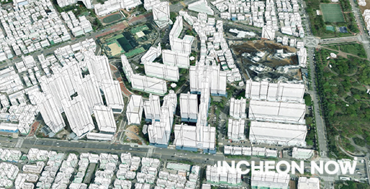
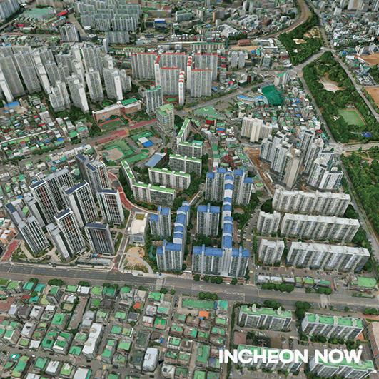
3D map before improvement > 3D map after improvement
READING THE CITY IN THREE DIMENSIONS
도시를 입체적으로 읽다
As intelligent technologies are increasingly integrated into urban life, daily routines have become more seamless—particularly through map services. When combined with virtual and augmented reality, maps have evolved into three-dimensional representations that offer spatial information closely aligned with real-world environments.
스마트 기술이 도시 곳곳에 스며들면서 일상은 한층 편리해졌다. 그중 하나가 지도 서비스다.
가상·증강현실 기술과 결합된 지도는 2차원을 넘어 3차원으로 확장되며, 현실과 유사한 공간 정보를 제공한다.
Since 2019, Incheon has been developing 3D spatial data biannually, providing a virtual city service at LOD 2.5 that accurately represents building structures. This 3D data is utilized across various sectors, including skyline analysis, redevelopment planning, and urban infrastructure management. In tourism, it enables users to virtually explore major attractions beforehand, improving accessibility and convenience.
이러한 3D 공간정보는 다양한 분야에서 활용된다. 건물 배치를 통해 스카이라인과 조망권을 직관적으로 파악할 수 있으며, 재개발 및 건축 인허가 과정에서도 효율적인 의사결정을 지원한다. 또한 지하매설물 등 도시시설물의 전산화를 통해 관리 정확도를 높이고, 관광 분야에서는 주요 관광지와 문화자산을 사전에 체험할 수 있어 여행의 접근성과 편의성을 높이고 있다.
인천은 2019년부터 격년 주기로 3차원공간정보 데이터 구축 사업을 추진해왔으며, 건물의 지붕 형태까지 정교하게 구현한 LOD(Level of Detail) 2.5 수준의 3차원 가상도시 서비스를 제공해왔다.
BUILDING KOREA’S FIRST METROPOLITAN HIGH-RESOLUTION 3D MAP
광역단위 최초, 3차원 고해상도 지도를 구축하다
Incheon has recently completed a high-resolution 3D modeling project with an accuracy of approximately 3 cm, further enhancing its spatial data capabilities. Utilizing drone technology, the city obtained more precise data and created detailed models that include building façades. By adopting 3D mesh technology, updates can now be performed at roughly one-fifth the previous cost, boosting efficiency and savings. This development is expected to improve administrative processes and deliver more practical spatial information services to residents.
최근 인천이 ‘3cm급 고해상도 3D 입체모델 구축 사업’을 완료하며 공간정보 기술을 한단계 끌어올렸다. 특히 드론을 활용해 기존 위성 및 항공사진 대비 더욱 정밀한 데이터를 확보했으며, 건물 외벽까지 구현한 고도화된 3D 모델을 구축했다는 점에서 의미가 크다. 또한 3차원 메쉬 기술을 도입해 기존 대비 약 5분의 1 수준의 비용으로 갱신이 가능해지며, 경제성과 효율성을 동시에 확보했다. 이는 행정 효율성 향상은 물론 시민에게 보다 실질적인 공간정보 서비스를 제공하는 기반이 될 것으로 기대된다.

Go to the photorealistic 3D map website
실사형입체지도 3D 사이트 바로가기
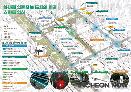
Smart Design Special Zone master plan
스마트 디자인 특구 마스터플랜
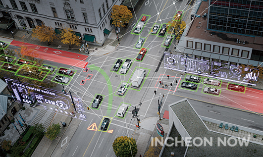
MANAGING THE CITY WITH ADVANCED TECHNOLOGY
첨단 기술로 도시를 관리하다
Incheon is implementing smart technologies throughout the city to serve as a safety net in everyday life. By integrating innovations into transportation, crime prevention, and disaster response, the city is enhancing its resilience. As part of this initiative, Incheon is creating Korea’s first Smart Design Special Zone.
The project integrates advanced technology with public design to develop a citizenfocused environment in Guwol-dong, an area concentrated with key public facilities and commercial zones. The design was finalized in September 2025, contracts were concluded in December, and full-scale implementation started in January 2026.
인천은 스마트 기술이 시민들의 일상 속에서 안정망으로 작동하도록 도시 전반에 적용하고 있다. 교통, 범죄, 재난 등 시민 생활과 밀접한 영역에 기술을 접목해 도시 대응 역량을 강화하는 것이 핵심이다. 이러한 전략의 일환으로 인천시는 전국 최초로 ‘스마트 디자인 특구’를 조성한다.
스마트디자인 특구는 첨단 기술과 공공디자인을 결합해 시민 중심의 도시 환경을 구축하는 사업이다. 대상지는 학교, 인천시청, 애뜰광장 등 주요 공공시설과 병원‧상업‧업무시설이 밀집한 구월동 일원으로 선정됐다. 2025년 9월 설계를 완료하고 같은해 12월 공사 계약을 마쳤으며, 2026년 1월부터 본격적인 사업이 추진되고 있다.
CREATING A SAFER AND MORE CONVENIENT ENVIRONMENT
안전하고 편리한 환경을 제공하다
The project focuses on four main areas. Initially, “Smart Emergency Zones” and “Smart Safe School Routes” will be implemented at high-pedestriantraffic sites, such as the Gil Hospital Intersection and the Guwol Middle School Intersection.
Crosswalk safety will be improved through the implementation of voice-guided pedestrian signals, in-ground traffic lights, and countdown timers. Aeteul Plaza, located in front of City Hall, will be converted into a “Smart Park” featuring exercise equipment for seniors, smart benches, and bicycle racks, establishing a welcoming public space for all residents.
Major pedestrian routes with high foot traffic will be transformed into “Smart Pedestrian Safety Streets,” featuring automated smart shade structures, media poles offering real-time information, and smart benches equipped with heating and wireless charging. Additionally, intelligent lighting systems will adjust brightness in response to movement to enhance safety and energy efficiency. Before full deployment, a detailed site analysis will be conducted, and plans may be modified based on on-site conditions.
사업은 네 가지로 추진된다. 먼저 ‘스마트 응급구역’과 ‘스마트 안전통학로’를 조성한다. 대상지는 노인과 보행약자의 통행이 많은 길병원 사거리와 학생들의 이동이 잦은 구월중학교 삼거리다. 이곳에는 보행신호 음성안내 장치 70개와 바닥형 보행신호등 530개를 횡단보도에 설치해 보행 안전을 강화한다. 여기에 적색 잔여시간 표시기 70개를 추가 도입해 대기 시간에 대한 불안감을 줄이고, 보다 안전한 횡단 환경을 조성한다.
시청 앞 애뜰광장은 ‘스마트 공원’으로 탈바꿈한다. 어르신을 위한 운동기구를 비롯해 스마트 벤치와 자전거 거치대 등을 설치해 시민 누구나 편리하게 이용할 수 있는 휴식 공간으로 조성한다.
또한 유동 인구가 많은 주요 통행로는 ‘스마트 보행안전거리’로 정비된다. 온도와 풍속을 감지해 자동으로 개폐되는 스마트 그늘막을 설치하고, 스마트 미디어폴을 통해 다양한 생활정보를 제공한다. 스마트 벤치에는 온열 기능과 스마트폰 무선충전 기능을 적용해 계절과 관계없이 쾌적한 이용 환경을 마련했으며 보안등에는 평시 60% 밝기를 유지하다가 인체 움직임이 감지되면 100%로 밝아지는 지능형 조명 시스템을 도입한다. 본격적인 사업 착수에 앞서 현장 여건을 면멸히 분석할 예정이며, 세부 내용은 상황에 따라 조정될 수 있다.